What is the Upper West Side?
A bit of a silly question, isn’t it? One easily answered by pointing to the below image, or by reciting the first couple of lines on Wikipedia: The Upper West Side (UWS) is a neighborhood in the borough of Manhattan in New York City. It is bounded by Central Park on the east, the Hudson River on the west, West 59th Street to the south, and West 110th Street to the north.
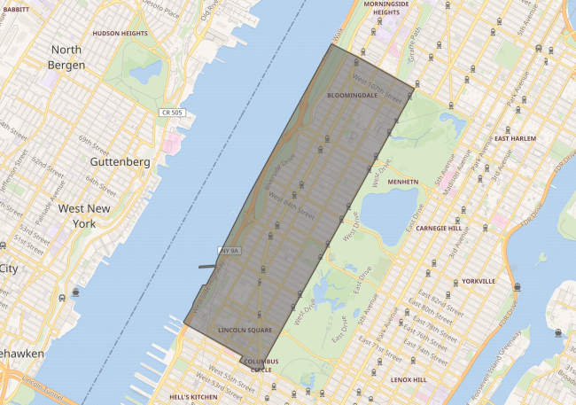 From wikipedia
Neither answer is inaccurate. The Upper West Side’s a neighbourhood defined by those borders. A pretty awesome neighbourhood, in my opinion. Yet it is one whose reality, like any neighbourhood, is brought about by people and the (formal or informal) governance structures those people create.
I’ve been trying to pay closer attention to those structures. There are plenty of ways the Upper West Side could become more awesome, I firmly believe that, but I even more firmly believe that it’s important to know the current state of a system before getting into potential new states. Change is a vector, where both source and destination define its nature.
Let’s dig in to that source.
Demographics
NYC’s Population Fact Finder is a neat tool that lets you look at census and American Community Survey (ACS) data by various geographical areas. Looking at the 2020 census data for the Upper West Side, we see the following statistics.
| Upper West Side | New York City | |
| Total Population | 224,215 | 8.8 million |
| Housing Units | 127,865 | 3.6 million |
| Average household size | 1.93 | 2.55 |
| Under 18 % | 14.8% | 19.8% |
| Hispanic % | 14.8% | 28.3% |
| White % | 63% | 30.9% |
| Black % | 6.7% | 20.2% |
| Asian % | 10.4% | 15.6% |
| Other/Mixed % | 5.2% | 5.0% |
Political Boundaries
Council District
The City Council is NYC’s legislature, with 51 voting members, each elected from a Council District.
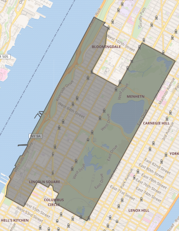
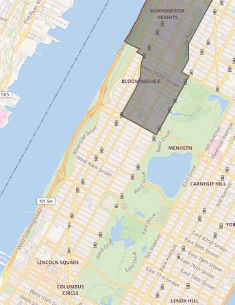
Council District 6, and (part of) Council District 7
As seen above, the bulk of the Upper West Side is found in District 6, along with Central Park, a portion of Riverside Park and a bit of Hell’s Kitchen. Its current councilperson is Gale Brewer.
The remaining area - Manhattan Valley - can be found in District 7, whose current councilperson is Shaun Abreu.
Community District
Another way in which NYC is divided is into 59 Community Districts, each with an associated Community Board. A given district’s board is composed of 50 members - every other year, half the board is appointed for two-year terms by the relevant borough president.
Community boards have an advisory role in our city government, performing functions in licensure (e.g. liquor licenses), liaison (addressing resident concerns raised in open fora), and land use (they have their own stage in ULURP, the city’s process for changes in zoning)
The Upper West Side is approximately coterminous with Manhattan Community District 7, as shown in this diagram of Manhattan’s community boards.
Land Use
All of the images in this section come from ZoLa (no, not the wedding website), a map of NYC’s zoning and land use.
Zoning Districts
Below is a map of the UWS’s zoning districts - yellow indicates residential uses, and red indicates commercial uses. The alphanumeric label indicates specific types of residential/commercial buildings and uses that are permitted within that area.
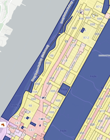
For instance, R8B is a type of residential district meant to encourage six-story apartment buildings, while C2-7A describes a commercial district meant to be along a major thoroughfare in a residential area.
However, zoning districts aren’t the whole story in a neighbourhood like the Upper West Side, because there also exists…
Historic Districts and Landmarks
Landmarks are structures that have been designated by the Landmarks Preservation Commission (LPC) to be of especial historic, cultural or aesthetic significance. Any changes to landmarks requires review and approval from the commission, and property owners are required to maintain the building’s current exterior. For instance, the Empire State Building is a landmarked building.
Historic districts are areas of neighbourhoods that are deemed to be of significant cultural/aesthetic importance, like a common style of architecture shared by the buildings in that area. Any changes to buildings in those areas, or even construction on empty lots within a historic district, have to be approved by the LPC. (This can lead to scenarios like attempts to turn a parking lot on 250 Water Street into housing failing for decades, because it’s a parking lot in a historic district.)
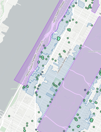
Above is a map of the distribution of historic districts and landmarked buildings across the Upper West Side. Blue regions are historic districts, the circles are landmarks, and the purple regions are scenic landmarks. As you can see, a good chunk of the Upper West Side is devoted to historic districts.
Other Examinations
There are of course other ways by which to look at the Upper West Side. There are other political boundaries the neighbourhood is part of, such as those for state-level and federal-level offices that affect it. Other metrics too, like those on this densitydb entry for the Upper West Side. Likely more I don’t even know about.
But I think this overview is a good starting point, so for now we’ll stop here.